
Aerial Mapping vs Traditional Surveying: Why Precision-Aerial is the Clear Choice for Developers, Engineers, and Surveyors
In the field of land development, accurate and detailed mapping is crucial for successful project planning and execution. Traditionally, land surveying has been the go-to method for capturing data. However, with the advancements in technology, aerial mapping has emerged as a game-changer. In this article, we will explore the key differences between aerial mapping and traditional surveying, and why Precision-Aerial is the clear choice for developers seeking efficient, accurate, and cost-effective solutions.
Accuracy and Precision:
Precision-Aerial, with its cutting-edge drone technology, offers unmatched relative accuracy and precision in mapping. Traditional surveying methods often involve manual measurements and are prone to human errors. On the other hand, drones equipped with high-resolution cameras and LiDAR systems capture data with exceptional detail and consistency, leading to precise repeatable results. This level of accuracy becomes invaluable when it comes to crucial decisions like site planning and volumetric calculations.
Speed and Efficiency:
When it comes to many land development projects, time is of the essence. Traditional surveying methods can be time-consuming, involving manual labor, complex setups, and lengthy data processing. Aerial mapping, on the other hand, significantly speeds up the process. Drones equipped with advanced sensors can cover large areas quickly, collecting data in a fraction of the time required by traditional surveying methods. Precision-Aerial's efficient workflow, from data capture to processing, allows developers, engineers, and surveyors to save time and expedite their projects.
Cost-Effectiveness:
Cost considerations play a vital role in land development projects. Traditional surveying can be expensive due to the extensive manpower, equipment, and time required. Precision-Aerial offers a cost-effective alternative by leveraging drone technology. With streamlined data collection and processing, the overhead costs are significantly reduced, making Precision-Aerial a more affordable option for developers. This cost-effectiveness allows developers to allocate their budgets more efficiently and maximize their resources.
Data Visualization and Analysis:
One of the key advantages of aerial mapping is the ability to create detailed 3D models as well as accurate topographic maps. Precision-Aerial's advanced mapping technology provides their customers with a comprehensive view of the project site, allowing for better visualization and analysis. These detailed models facilitate informed decision-making, enabling developers to identify potential challenges and optimize their designs. Traditional surveying methods often lack this level of visual representation, limiting the depth of analysis and decision-making capabilities.
Safety and Risk Mitigation:
Safety is paramount in any land development project. Precision-Aerial's drone mapping technology reduces the need for personnel to be physically present in hazardous or inaccessible areas. This minimizes the risk of accidents and ensures the safety of surveyors and construction teams. Additionally, by accurately identifying existing features and potential obstacles, such as underground utilities or unstable terrain, Precision-Aerial's mapping solutions contribute to effective risk mitigation strategies.
In the ever-evolving field of land development, Precision-Aerial stands as the clear choice for developers, engineers, and surveyors seeking accurate, efficient, and cost-effective mapping solutions. By embracing aerial mapping technology, Precision-Aerial's customers can benefit from superior accuracy, increased speed, enhanced cost-effectiveness, comprehensive data visualization, and improved safety. Precision-Aerial's commitment to innovation and excellence empowers developers to make informed decisions, streamline their projects, and achieve successful outcomes in a rapidly changing industry.

Drone Photography and Videography: Tips and Tricks for Stunning Results
Drone photography and videography have opened up a new world of possibilities for capturing stunning and unique perspectives. However, getting the perfect shot can be a challenge, especially for beginners. To achieve the best results, it's important to plan your shots carefully, adjust your settings, choose the right equipment, and frame your shots thoughtfully. By following these tips and techniques, you can create compelling and visually appealing drone photos and videos that tell a story and engage your audience. With practice and patience, you can take your drone photography and videography to the next level and stand out from the crowd
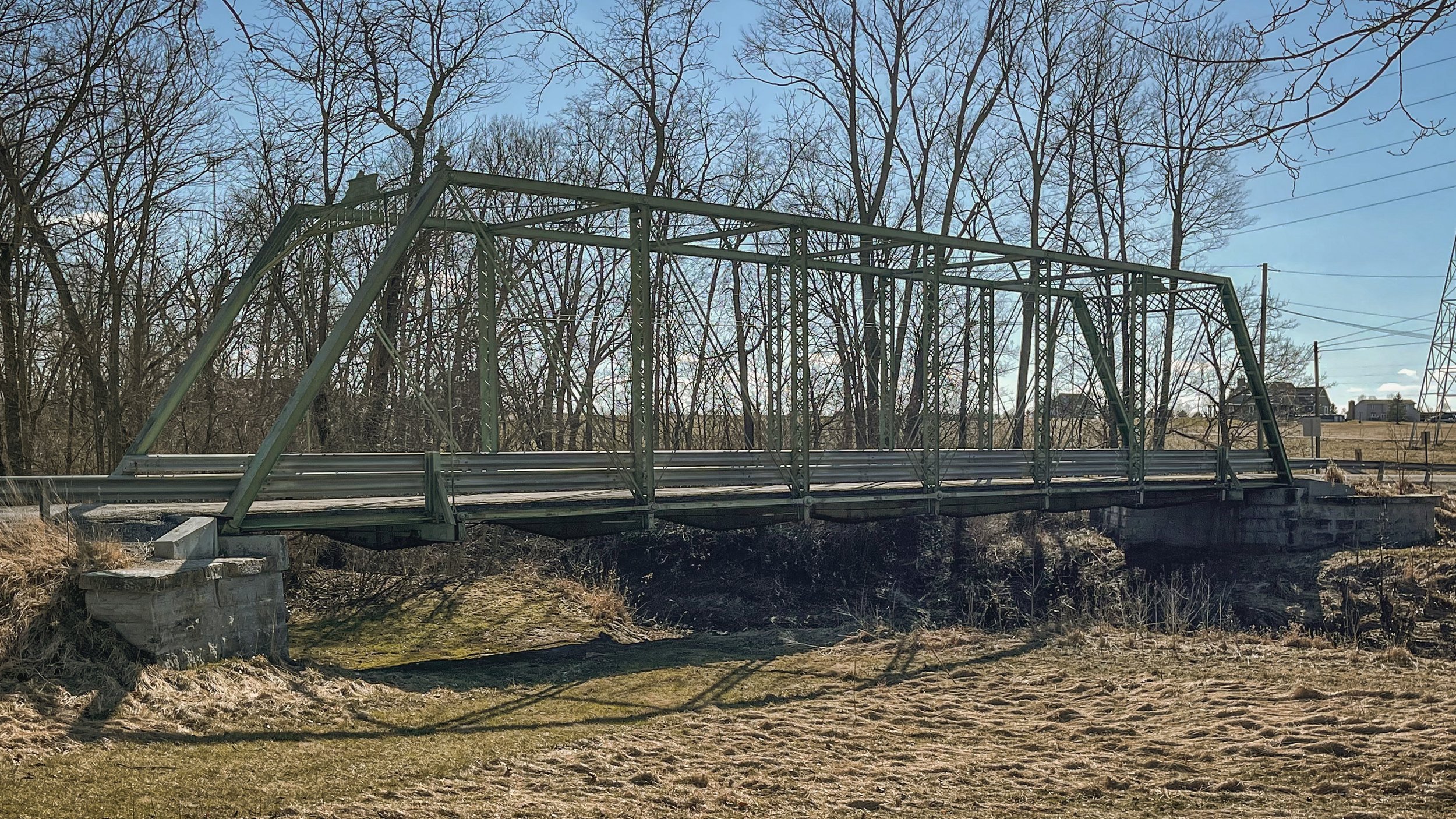
Using Drones for Infrastructure Inspections: Bridges, Pipelines, and Power Lines
Drones have emerged as a game-changer for infrastructure inspections, offering a safer, cost-effective, and more efficient way to perform these tasks. Traditional inspection methods can be dangerous and time-consuming, involving working at heights or in hazardous environments. However, drones can fly over these areas or confined spaces, eliminating the need for workers to put themselves in harm's way.
One of the significant advantages of using drones for infrastructure inspections is cost-effectiveness. Drones can cover a larger area in a shorter amount of time, reducing labor costs and minimizing the need for equipment and resources. In addition, they can capture high-resolution images and video, providing a more accurate and detailed view of infrastructure components, helping to identify potential problems before they become major issues.
Another significant benefit of using drones for infrastructure inspections is their ability to create 3D maps and models. By using photogrammetry techniques, drones can take overlapping photos of infrastructure, which can be stitched together to create a 3D model. This allows engineers and inspectors to examine the infrastructure in greater detail, identify potential problems that may not be visible in traditional 2D photos or videos, and make informed decisions.
Drones also improve inspection efficiency by reducing the time it takes to complete inspections. This means that inspections can be done more frequently, allowing for earlier detection of potential problems. Overall, using drones for infrastructure inspections is an ideal solution for companies and organizations responsible for maintaining infrastructure, as it can improve safety, save time and money, provide more accurate data, and allow for the creation of 3D models
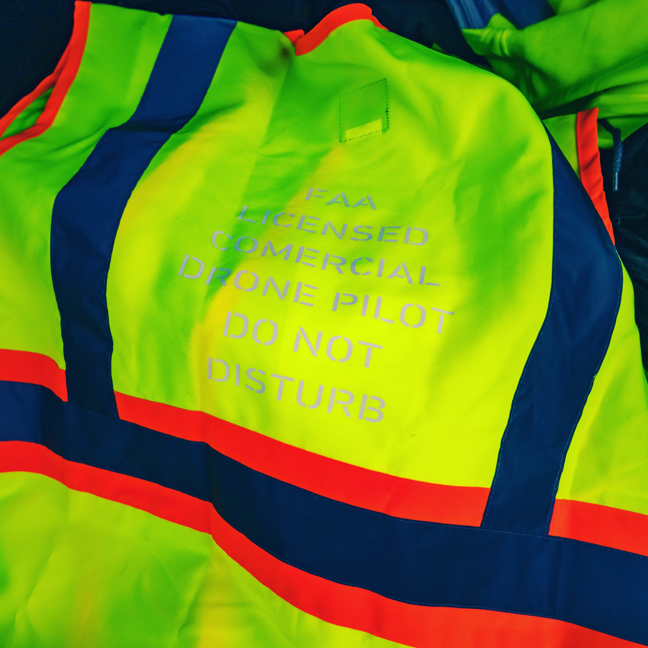
Protecting Your Business and Your People: The Benefits of PPE for Drone Service Providers
As the use of drones becomes more widespread across various industries, it is crucial to prioritize safety and minimize the risks involved in drone operations. One of the most effective ways to achieve this is by using personal protective equipment (PPE). PPE can protect drone operators from accidents and injuries, hazards, and demonstrate professionalism to clients.

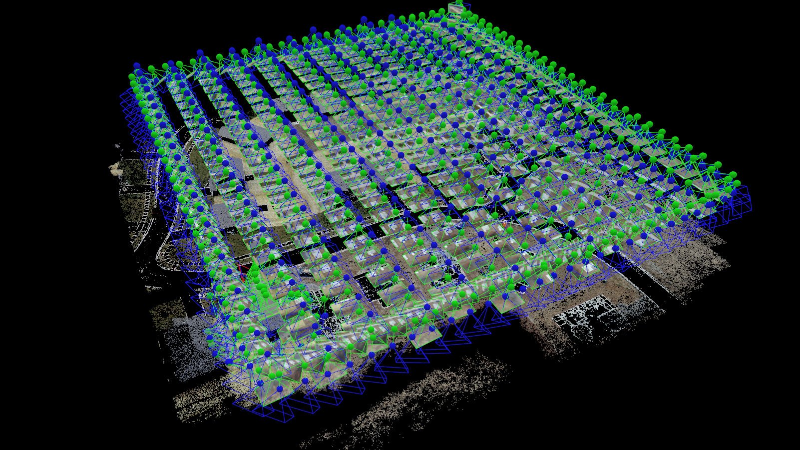
Double Grid Pattern vs Single Grid Pattern: Which is best for your project
The choice of a double grid pattern or a single grid pattern in surveying, engineering, and construction depends on the specific requirements of the project. Understanding the benefits and drawbacks of each pattern is crucial in determining the best choice. The double grid pattern is ideal for projects where a high level of detail is required, such as creating accurate 3D models of terrain and structures, while the single grid pattern is best for projects where speed and cost are a concern, such as environmental and agricultural monitoring. The use of aerial mapping and photogrammetry, regardless of the chosen flight pattern, can provide valuable data for a project and aid in achieving its goals.

Maximize Your Home's Protection: The Benefits of Mapping Your Property and Creating an Orthomosaic.
Mapping your property and creating an Orthomosaic brings numerous benefits to home owners. It can simplify the process of making insurance claims in case of natural disasters, resolve disputes, increase property value, and aid in emergency response. A detailed and accurate map of your property provides a permanent record of its state and can be used as a tool in various situations. Invest in mapping your property today to protect your investment and enjoy peace of mind for years to come.

What is drone mapping used for you ask?
Drone mapping is revolutionizing the way we view and interact with the world. This form of aerial surveying uses drones equipped with cameras or sensors to capture images from above and create detailed 3D maps or models of the area surveyed. From land surveying and construction to environmental monitoring and real estate, drone mapping has numerous applications and is providing valuable insights and perspectives in a variety of industries. As drone technology continues to evolve, the possibilities for drone mapping are nearly endless

How Drone Technology is Revolutionizing Real Estate
Drones are revolutionizing the real estate industry by providing a comprehensive virtual tour of properties, including 3D models, 360° tours, fly-through videos, and high resolution photos and videos. This type of immersive experience is invaluable for realtors and potential buyers, as it gives them an insight into properties they may not be able to visit in person. Drones are quickly becoming an indispensable tool for real estate professionals and are proving to be a powerful tool for showcasing properties.


How to Choose the Right Drone Service Provider for Your Business
Are you in need of a reliable drone service provider for your business? With the increasing popularity of drone services for construction, mining, surveying, and engineering, you may be overwhelmed by the number of providers in the market. Before selecting a drone service provider, it is important to consider a few key factors. First, make sure to consider the experience and qualifications of the drone service provider. Are they qualified to perform the services you need? Are they experienced in the area of your business you need help with? Do they have the right equipment and software to get the job done? Second, ensure that the drone service provider is reliable and offers quality services. Ask for references or read reviews to gain a better understanding of their services. Third, consider the cost of the drone services. Make sure to ask for quotes and compare them to find the best deal. Fourth, ask about the drone service provider’s customer service and security protocols. With the right provider, you can enjoy the benefits of drone services for your construction, mining and aggregates, surveying and engineering needs.

How Drones are Transforming Roofing Contractor Efficiency
Drones make the job much safer and more efficient for roofing Contractors and inspectors. With the latest drone technology, contractors can quickly inspect rooftops and get on with the job.
In summary, drones are quickly revolutionizing the way roofing contractors work, allowing them to be more efficient than ever before. With the help of drones, contractors can accurately measure rooftops, create 3D models, document progress, and inspect rooftops safely and efficiently. This helps contractors save time, money, and potentially lives. By utilizing the latest drone technology, contractors can quickly complete projects and get back to work.

Flying Safely and Responsibly in Fort Wayne: Know the Drone Ordinance Before You Take Flight!
If you’re planning to fly a drone in Fort Wayne, Indiana, it’s important to be aware of the city’s ordinance for drone operations. The City of Fort Wayne has a municipal code, Section 96.30, that requires drone pilots to notify the city before flight in certain areas. Specifically, the ordinance requires notification of flights within 500 yards of a city-permitted public event such as a festival, block party or parade.
To notify the city of your impending flight, complete a simple online form on your mobile phone or tablet here: https://eforms.acfw.net/iFiller/iFiller.jsp?fref=3d8bd7b4-32da-4f7e-b5c7-4c0c7c26d82b. The Fort Wayne Police Department is responsible for enforcing the ordinance, with violations ranging from a warning to a fine of not less than $150 or more than $500 for each offense.
It’s important to remember that the ordinance does not constitute an approval process, and that drone pilots are expected to be aware of the laws and regulations for legal and safe commercial or non-commercial flight operations. Additionally, the ordinance prohibits any drone flights that are conducted in an unsafe manner.
Flying a drone in Fort Wayne can be a great way to capture some amazing aerial views, but it’s important to be aware of the ordinances to ensure you fly safely and responsibly.

Maximizing Productivity and Minimizing Risks: How Drones are Changing the Face of Mining and Quarries
The mining and aggregates industries in the Fort Wayne area are facing a unique set of challenges, from ensuring worker safety to maximizing productivity and minimizing costs. One solution that is proving to be highly effective in addressing these challenges is the use of drones. Drones, also known as unmanned aerial vehicles (UAVs), are becoming an increasingly important tool in the mining and aggregates industries, helping to improve safety, save time, and reduce costs. In this article, we will explore the many benefits of using drones in the mining and aggregates industries and how this technology is revolutionizing the way these industries operate.
Revolutionizing Surveying and Engineering: How Drones are Transforming the Industry
In an ever-changing world, the need for efficient and precise surveying and engineering is paramount. With the advent of drone technology, surveyors and engineers are now able to revolutionize their daily tasks with a safe and efficient way to gather data. By using drones to capture aerial images and data, surveyors and engineers can create detailed maps, measure elevations and distances, and detect objects or features on the ground. Additionally, drones can also be used to inspect hazardous or hard-to-access areas, allowing surveyors and engineers to conduct inspections without putting themselves in harm’s way. With the power of drones, surveyors and engineers can now revolutionize their daily tasks in a faster and more accurate manner.